
|
Our plans for the Lower James River Center at Colonial National Historical Park enhance this important hub for environmental education - connecting more students and the Lower James River region with the river and advancing our vision of a fully healthy river supporting thriving communities.
Through a partnership with the National Park Service, JRA currently utilizes an existing facility to lead education programs, conduct student activities and host community programs. The site is comprised of a building originally developed as a visitor contact station, a large parking lot and two National Park Service trails. |
|
History & Location Significance
|
The Lower James River Center, located at Neck O’Land on the Colonial Parkway, resides on historic property that witnessed the birth of Virginia and our nation. In 1607 English settlers considered a neighboring location but Captain Gabriel Archer argued in favor of this location, and in his honor the area was named “Archer’s Hope.” Unable to get ships close to shore due to shallow water, the English moved on and the next day chose a site across Back River and called it Jamestown. By 1619, the English settlement had expanded beyond Jamestown Island to this location between Powhatan Creek and Mill Creek, called Neck of Land.
Across centuries the area has served as a crossroads. Powhatan Indians walked ancient footpaths or paddled past in dugout canoes. By the eighteenth century, English, African Americans, and European immigrants dwelled here and, by the nineteenth century, used the road that connected the mainland with Jamestown Island. Between 1607 and 1609 Captain John Smith and his crew of adventures mapped nearly 3,000 miles of the Chesapeake Bay and its rivers, and documented the different native communities along the James River. Today Neck of Land is a gateway to the Captain John Smith Chesapeake National Historic Trail. |
|
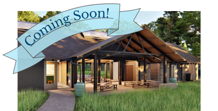
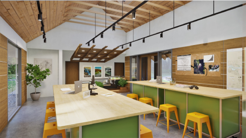
With expert guidance from 3North Architects, JRA has developed a master plan of enhancements for the site including:
- Enclosing an existing breezeway to create a large classroom space with space for up to sixty students and enhancing the existing inside space with interactive teaching tools including a “riverquarium” and the latest educational technology that allows students to see their local environment in a global perspective.
- Installing a pavilion, developed with sensitivity to the surrounding nature, which can serve as an outdoor classroom.
- Creating dedicated areas to explore historic topics related to the river such as its importance to indigenous people, through dugout canoe and shad planking exhibits.
- Highlighting environmentally conscious features that not only benefit the entire facility but also serve as demonstration areas for learning activities such as the installation of solar panels, rain barrels, a rain garden and composting area.
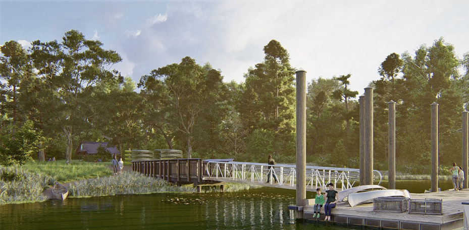
Additional plans for the site developed by Vanasse Hangen Brustlin, Inc. (VHB) include a new water access on Back River, a tributary of the James River. This will be the first water access site designated within the Colonial National Historical Park. and will provide an accessible and convenient location for on-water activities. A floating boat dock and paddlecraft launches will provide multiple ways for JRA’s fleet of canoes and kayaks to enter the water and accommodate larger motorized vessels, including JRA’s forthcoming Floating Classroom. Boat access is crucial for delivering hands-on, river-based environmental education opportunities and ensuring area youth engage with quality experiences on the James River.
|
The building and facilities will incorporate the following themes:
Celebrating the importance of the James River and launching lifelong lovers of the river
Reflecting the diversity of what the James offers and the different communities we serve
Fostering a confluence of ideas and providing a catalyst for the community
|
Budget Update
$1,420,368 Goal 1,326,823 Raised to date $93,545 left to raise For more information on the campaign or to make a gift, please contact Ashleigh Moody, VP of Development at [email protected].
|